UPDATED: At the May 2025 Council meeting, Option 2 was chosen. Thanks to everyone, particularly the future school parents, who made their views known. “The balance of the Smith Street upgrades will be delivered in the longer term (2045+) when existing commercial properties redevelop into residential uses”. Maybe the children of the current children will enjoy those upgrades!
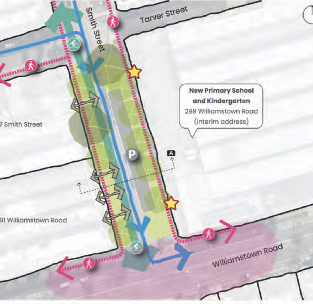
There is a proposal before council to upgrade the southern section of Smith St, Port Melbourne - between Tarver St and Williamstown Rd - where the new Fishermans Bend Primary School will open in 2026 and a Kindergarten in 2027.
Option 1, the original plan sent out to community consultation in 2024, is to create a reduced speed, one-way street where traffic enters from the north end, and then only turns left onto Williamstown Rd.
Option 1
prioritises kids and their families, with footpaths and bike lanes for kids arriving on foot, scooter and bike
reduces school traffic by making alternatives more attractive
Has parking for school drop-offs
is a one-way street allowing access for adjacent businesses, but discourages trucks and through traffic
However without further consultation, a new option (Option 2) is being presented to Council this Wednesday (7th May) as the preferred option. Option 2
Removes the bike path and footpaths from the western side of Smith St
Prioritises use of the street by trucks and two-way through traffic, with a limited truck ban only between 8.00-9.30am and 2.30-4.00pm. Currently 95 trucks and 2200 vehicles per day use Smith St.
What was in the original plan (OPtion 1)?
There is provision for a safe drop-off and pick-up space in a new ‘children’s education precinct’.
Safe easy access to the school & kindergarten
The new safer green space that is created as a result of reducing car and truck traffic lanes (to one-way only) and upgrading the footpaths will include a linear park for more play area, and safe, easy access for students with new trees, increased lighting and a protected active transport pathway.
Safer from traffic.
This upgrade will rein in the amount and speed of traffic by minimising the number of trucks taking shortcuts, and preventing all vehicles from racing across busy Williamstown Road as they turn right.
When a new signalised pedestrian crossing across Williamstown Rd is added, the precinct will safely connect pedestrians and cyclists to Garden City, the Bay Trail and beyond.
Walking, riding or scootering to school will be an easier, safer and more pleasant experience for local families.
Fishermans Bend is slowly developing from industrial decay into residential infrastructure and housing for families. But most of the dwellings are apartments without gardens and play space.
So positive changes to local pockets like this are vital to creating safer streets and parks for children and adults alike.
Connecting communities, reducing congestion.
As these living pockets of Fishermans Bend develop, so too the networks of safe paths will connect together.
Eventually the active transport paths will enable the people who live and work in Port Phillip to walk, ride or scooter safely to the new employment and education precincts on the river side of Fishermans Bend, and further into the city.
Good city planning, and more parks.
City of Port Phillip is a municipality with some of the highest population density in the state, and that is only increasing. But in response, council has a good track record of reclaiming roadways and former wasteland and turning them into friendly, safe space for families.
Great examples include Mitford St / Poets Gve at Elwood Primary, Moubray St Community Park at Albert Park Primary, Lemnos Square at Albert Park College and Kirrip Park at South Melbourne Primary. And there’s a trial pocket park at St Kilda Primary.
Many of these places have become cherished parks that everyone in the community can enjoy outside school times.
what is in option 2?
In Option 2, the footpaths and bikepath on the west side of the road are removed— or rather, shifted to “stage 2” which will be in the “long term”. There is no schedule when this will happen… but the school is opening in 2026. Kids need attractive safe streets adjacent to their schools from day one, not in the never-never.
Trucks and through traffic will have easy access to Smith St. A limited truck ban between 8am-9:30am and 2:30pm-4pm is mooted, but it’s not clear how this will be enforced— and in any case, kids and families will be using the street throughout the day. Currently 2200 vehicles and 95 trucks on average use Smith St daily.
Two-way traffic and 40km/hr speeds. This is not a kid-friendly safe zone. The Australasian College of Road Safety says that “the risk of fatality for a pedestrian hit by a vehicle travelling at 30km/h is around 10%, compared to approximately 40% at 40km/h”. Moreover, it’s more effective to communicate the expected speed through the design of the road, than posted speed limits alone.
Why has this happened?
Legacy businesses have lobbied to maintain their truck and vehicle access to Smith St, at the expense of the future school kids. While it’s important that access is provided for the existing businesses, the priority should be on the future and enabling a transition to a sustainable, child-centred education precinct, where the necessary infrastructure is in place from day one. Visitor access to these businesses does not require two-way traffic— visitors parking on Smith St can access from the north, while there is alternative on-street parking on both Williamstown and Tarver Streets.
could we be more ambitious?
While Option 1 represents best practice for our LGA, we could be going further.
In Paris, hundreds of schools have school streets, where the streets immediately in front of the school have been closed to vehicles, but opened to kids walking, cycling and scootering.
Streetfilms have made short Youtube video describing the phenomenon of Paris School Streets.
Could the south end of Smith St be completely closed to through traffic, allowing extra circulation and green space for the school kids and neighbours? This would require negotiation with the legacy businesses who have entrances on Smith St, and also thought given to safe places for a drop-off zone.
Another option is to plan a transition to a full closure in coming years as the neighbourhood character changes from warehouses to residential/businesses.