
This is the response that the Port Phillip BUG made to the recent streetscape plan for Ripponlea.
Glen Eira Avenue South Section: An excellent shared space.
We applaud councils proposals for the Glen Eira South Section of the Draft Ripponlea Streetscape and Open Space Plan. In the initial draft circulated it is not at all clear that the one way traffic for the proposed ‘shared space’ only applied to motorised vehicles. Since discussions with council officers clarified that this was to be a two way section for bicycles and micro-transport users, we are satisfied.
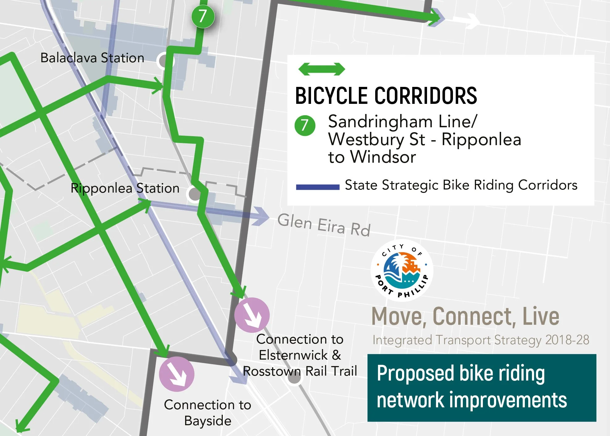
The reasoning for this is that this section is part of Council’s own bicycle network as outlined in the “Move, Connect, Live - Integrated Transport Strategy 2018-28” policy. Specifically, this route is part of the ‘#7 Sandringham Line / Westbury Street - Ripponlea to Windsor’ Route, as shown in the extracted and zoomed image below from that important policy document. The ITS is approved by council, and guides council decision making in building the City of Port Phillip’s present and future connected cycling networks.
This particular route is the major north-south connector route on the eastern side of the municipality for cyclists. And it is very well used by all active transport users. We also believe that this route is a priority over the incomplete Green Line proposal, which diverts blocks to the West of this section, and is not in current use nor construction stage.
When asked by council officers for our organisation’s preference for the surface of the proposed shared space, we reiterate that it should be something that communicates to vehicle drivers to slow down (such as pavers), but is not something that causes potential accidents for cyclists (such as bluestone).
We recommend installing raised speed inhibitors and rumble strips, but again, not with bluestone (as currently exists in that place). Bluestone loses the mortar between the blocks creating dangerous trip hazards for cyclists and pedestrians alike.
Glen Eira Avenue North: an opportunity for more parkland & footpaths, with less rat running and traffic danger.
PPBug supports council’s efforts to make larger, bolder civic spaces that prioritise pedestrianisation and green space, taking back roadway for the use of local people. We suggest that Council’s Draft Ripponlea Streetscape and Open Space Plan proposal just does not go far enough to do this.
We support PECAN’s suggestion that perhaps the grassed park on the north side of the Rippers Cafe could extend further north and take up part of Glen Eira Avenue North / Oak Grove. Further, we make a project expansion suggestion that addresses both reclaiming more roadway, and more importantly, reduces the amount of non-residential, commuter traffic that ‘rat runs’ though the precinct.
We propose that the section of Glen Eira Avenue North, from the end of Glen Eira Avenue South up to the alleyway that runs between Oak Grove and Elm Grove (or even all the way to Elm Grove itself), be made one lane, one way. And it should flow in the opposite direction to the proposed traffic direction of Glen Eira Avenue South shared space.
Currently that corner itself is much narrower than all the streets that feed it. It is a choke point, and dangerous blind spot for the current two way traffic. Larger municipal waste vehicles cannot go around that corner. Cars parked near the corner are swiped, and cars and trucks veer onto the wrong side of the road going around. For cyclists it is a red zone.
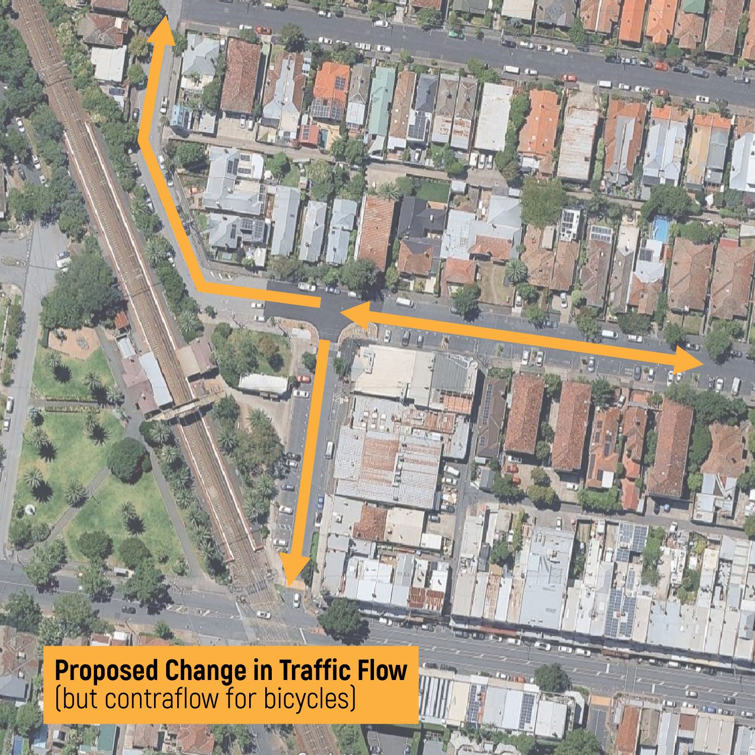
By making it one way traffic flowing north, we can eliminate 50% of the commuter / non-residential traffic travelling at haste south from Balaclava into Ripponlea (especially in evening peak).
Traffic could still enter (or exit) from Hotham Street / Oak Grove to the new precinct - but both Glen Eira Avenues (North and South) would then be used by vehicles as exiting movement only.
Almost all parking spaces, and the parking overflow for Ripponlea Village would not be affected by this. There would be three houses affected: they can still park in front of their properties, but approaching from the south (via Oak Grove) only.
With only one lane of traffic, there would be more room for expanded parkland and footpaths. And the curvature of the corner can be improved for smoother cornering and safer sight lines. Council may even get their garbage trucks around it without taking out a parked car or cyclist.
This would also facilitate safer Synagogue drop-offs, as they already enter from Hotham Street via Oak Grove, and exit south on Glen Eira Avenue South in a circular block loop. The entranceway to the new parking facilities in the rebuilding proposal for the Synagogue is on Oak Grove, so this works well with that.
We propose that with the traffic made calmer, this should be a safe contraflow arrangement for cyclists, as is the proposed Glen Eira Avenue South shared space, to keep the ITS bicycle network route #7 intact.
Oak Grove Section: a speedway that needs traffic calming, not parking reconfiguration.
Oak Grove is a broad tree-lined street that acts as overflow parking for the Ripponlea Village (both shoppers and deliveries), as well as being the main access thoroughfare for members of the Addas Israel Synagogue and their informal Childcare Centre mid-way down the street.
On sabbath the street has a very heavy pedestrian flow by orthodox congregants walking in observance to the synagogue. It is also currently a popular cut through for commuter traffic travelling between Balaclava (from Glen Eira Avenue North); Caulfield and Elsternwick (from Hotham Street); and Elwood and beyond (Glen Eira Avenue South). Commuters also regularly use Oak Grove to avoid the Hotham street and Glen Eira Road intersection, in both directions. As such, Oak Grove has overly heavy traffic flow for commercial vehicles, resident cars, visitor cars, cyclists and pedestrians. It is very dangerous and difficult with the current traffic speed and flow for cars reversing out of the parallel parking. Speeds in excess of the marked 40kph is very common, especially for the commuter cut-through traffic. Council itself has performed several traffic flow measuring tests over the last 5 years that have evidenced this hazardous situation.
Oak Grove needs traffic calming … urgently.
PPBug supports the PECAN submission that the removal and replanting of the relatively new trees from one side of the street to the other is nonsensical, as the argument does not pass critical analysis. The reasoning that these new trees will grow into the powerlines is not supported, as these trees are already substantially outset from the curb and the powerlines. The moving of trees that are already several years old, it is suggested by the consulting arborist, would not have a great chance of surviving replanting.
This would also involve a costly swapping of the parallel and angle parking from one side of the road to the other. The costs involved would be better spent on improving far more important aspects of this project.
What PPBug would much rather see included in the Oak Grove section of this master plan is significant traffic calming measures that increase opportunity for greenery without too much car parking loss. We suggest that either a chicane structure is built mid-way down the streets. Such a chicane design successfully exists nearby on Grosvenor Street. A chicane structure would increase tree planting opportunity whilst minimising car park loss.
Or at the very least, a number of raised platform speed reducers are needed, that could double as pedestrian crossings for the aforementioned heavy pedestrian traffic.
Glen Eira Road Section: Ripponlea Village, an historic activity zone with an arterial road flowing through it.
PPBug wholeheartedly backs council on its efforts to fulfil the longstanding PPBug call to have the speed limit on the State’s Glen Eira Road (in the Ripponlea Village section) reduced.
Whilst we would prefer that council requests the new State standard of 30kph for a busy activity zone such as this, 40kph would be acceptable. What would not be acceptable is a time restricted reduction of the speed limit, such has been suggested from 7am-7pm.
The Ripponlea Village is a day-and-night activity zone, not just daytime. Many commuting cyclists use Glen Eira Road, a State and Council Strategic Cycling corridor, connecting Elwood, Balaclava and Ripponlea to Caulfield and the Djerring Trail. Pedestrian and cyclists are in danger 24 hours a day from speeding traffic.
Currently there is an on-road cycling lane through the Village. We would prefer (as has been supported by many local residents and shoppers) a separated lane, and one on the curbside of the parking spaces.
Failing this we request that the current bike lane is resurfaced with a distinctive, highly visible colour.
The connecting points at the railway level crossing and at the Hotham Street intersection need a redesign. Currently there is no clear, straight line between the village bike lanes and the corresponding bike lanes on the other side of Hotham Street (in the Glen Eira municipality).
The level crossing itself is highly dangerous, with dangerously deep potholes, and no clear pathway for cyclists contending with traffic.