strategic cycling corridors

Anzac Station to Sandringham Strategic Cycling Corridor

In November 2025, Infrastructure Victoria released Victoria’s infrastructure strategy 2025–2055.   One key recommendation was to invest in 12 cycling corridors in Melbourne and a network of cycle corridors in Geelong, Ballarat, Bendigo and Wangaratta over the next 10 years.      Media release Full report. 

The map of the proposed Strategic Cycle Paths, laid out train-network style

Melbourne cycling corridors advocated by Infrastructure Victoria

The Anzac station to Sandringham (with a spur link to Moorabbin) would be a massively useful transport link for for the south-east. The Infrastructure Victoria report includes:

  • The benefit-cost ratio for this route is 2.4 - 3.5

  • The route proposed follows the Strategic Cycling Corridor path, and includes the already-built Anzac Station to St Kilda Junction, then continues down St Kilda Rd to Glen Huntly RD, where it follows New St to the beach, then follows Beach Rd to Sandringham.

  • The Moorabbin link follows South Rd

  • The proposed infrastructure for this route is mostly on-road protected bike lane, with bikes protected by bollards or parked cars.

Screenshot of the strategic cycling routes

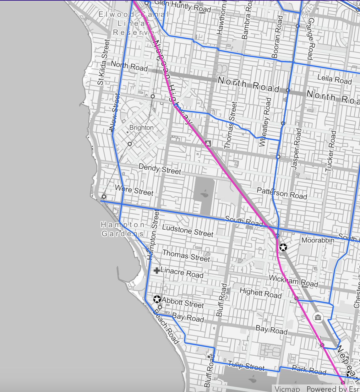
The strategic cycling routes in the area. The Anzac-Sandy route follows New St, with a branch along South Rd to Moorabbin. Via https://experience.arcgis.com/experience/53181c144cec477497e01d166c64a6eb

comments on the route

Here I am assuming that the route will follow the Strategic Cycling Corridor, though this is also somewhat unresolved. It may be that there are better options for some sections (leave a comment below to suggest these).

  • The section Anzac Station to St Kilda Junction is complete, though there is scope for improvement around intersections.

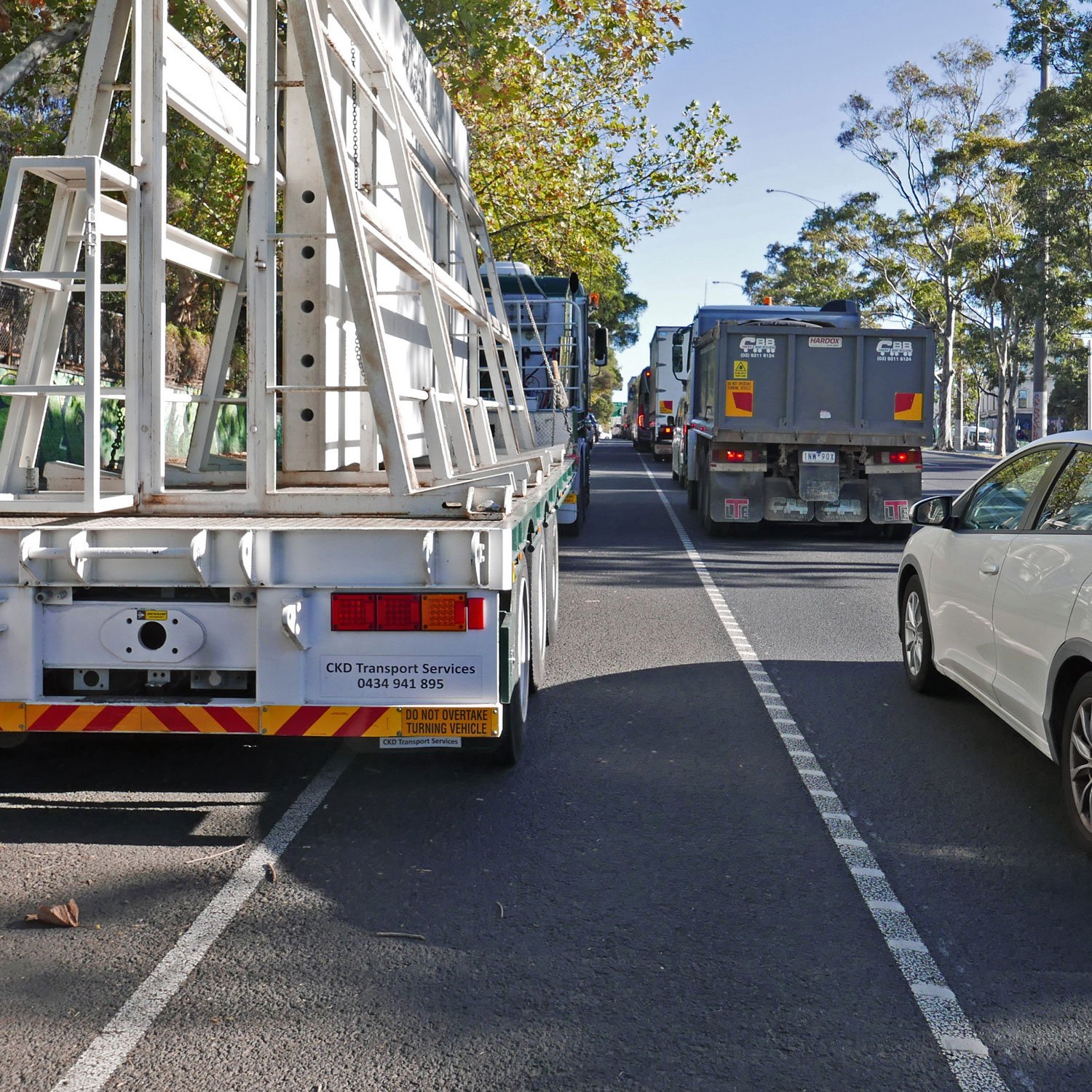
  • The section St Kilda Junction to Carlisle St was reportedly designed as part of the St Kilda Rd bike lanes, but not built for budget reasons. This section should be straightforward to implement, with a wide road. It is also critically needed, as heavy trucks take the lane adjacent to the painted bike lane to position themselves for the left turn onto Queens Rd.

  • The section Carlisle St to Glenhuntly Rd currently consists of a central road/tram corridor, and separated two-lane corridors in each direction, with a painted bike lane and a parking lane. This could have the same treatment as further north on St Kilda Rd, with a protected bike lane adjacent to the curb, and either a parking lane and single traffic lane, two traffic lanes, or where space permits, a parking lane and two traffic lanes.

  • The intersection Brighton Rd to New St, southwards looks challenging; at this point New St is one way (for vehicles) with a counterflow for bikes, so it isn’t possible to make this turn via car. There are also tram tracks. At the moment I’d make this turn with a hook turn, pausing either on the footpath or right in front of it, crossing Brighton Rd with the pedestrian lights, then connecting to New St via the footpath.

  • New St adjacent to Yalukit Willam and Elsternwick Parks has a quite wide corridor, with ample parking (either angle parking in some areas, a 90 deg parking area south of the roundabout on the road side of a service road, and other wise parallel parking).

  • New St south of these parks is generally on-street parallel parking on both sides, with a painted bike lane in the door zone. Intersections include large and small signalised intersections (eg North Rd, Martin St); large roundabouts (eg intersection at St Andrews/Well/Park Sts, and the complicated roundabout at Dendy St that crosses the rail line)

  • From the south end of New St, the indicated route does not join Beach Rd or the Bay Trail, but rather runs along the rail line. Between Holyrood and Orlando Streets, there is no existing path, but there is possibly room in the south side of the rail corridor.

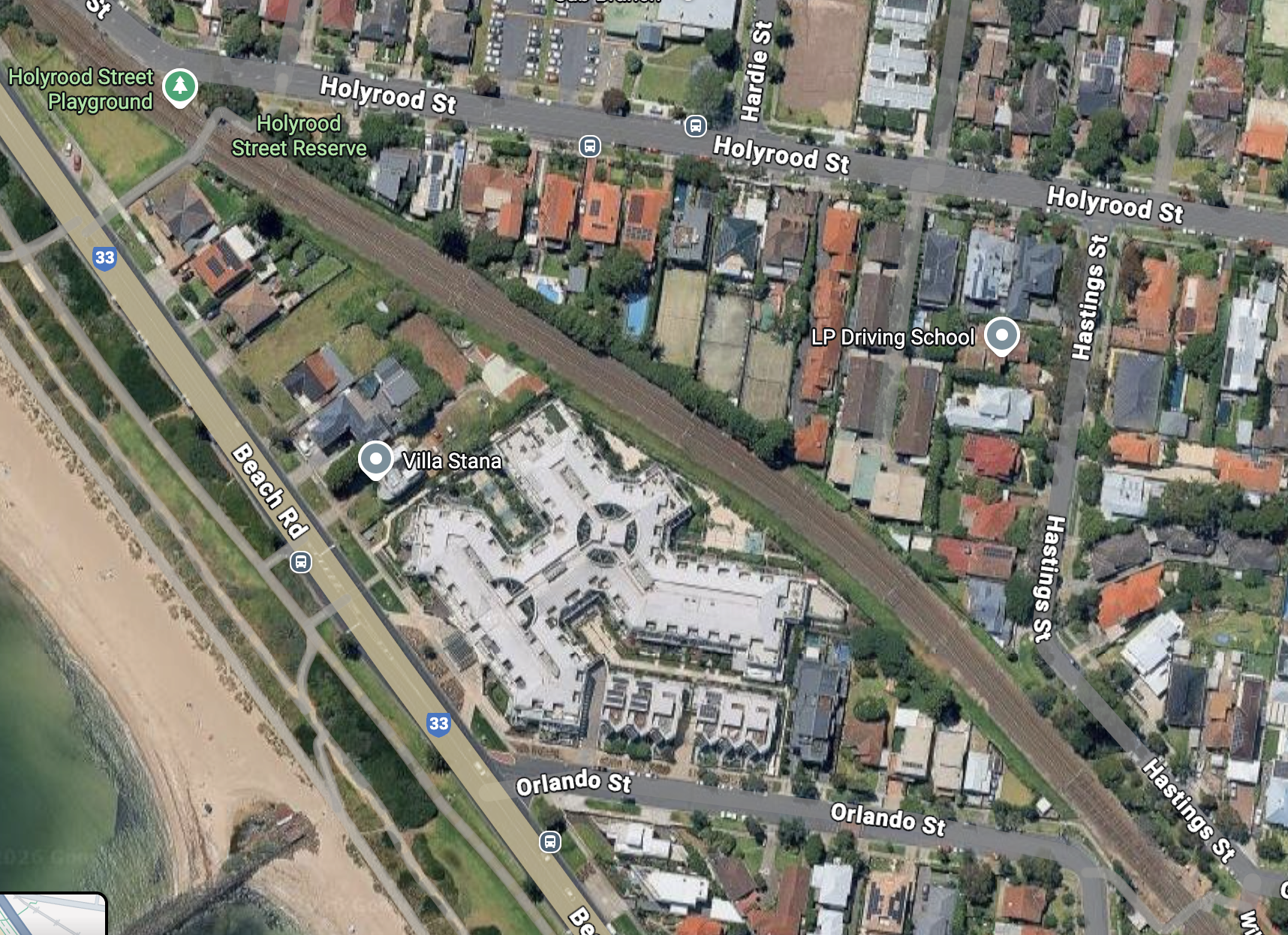
Rail corridor between Holyrood and Orlando St

  • South of Orlando there is no space for a path, but it may be possible to cross the rail line to the east side at the pedestrian level crossing and use Willis St, which is already a pleasant, low speed environment. This connects to Koolkuna Lane, which is currently one-way but could be modified to include contraflow movements for bikes. This brings us to Hampton station.

A narrow street with brick surface, with shrubs to the sides

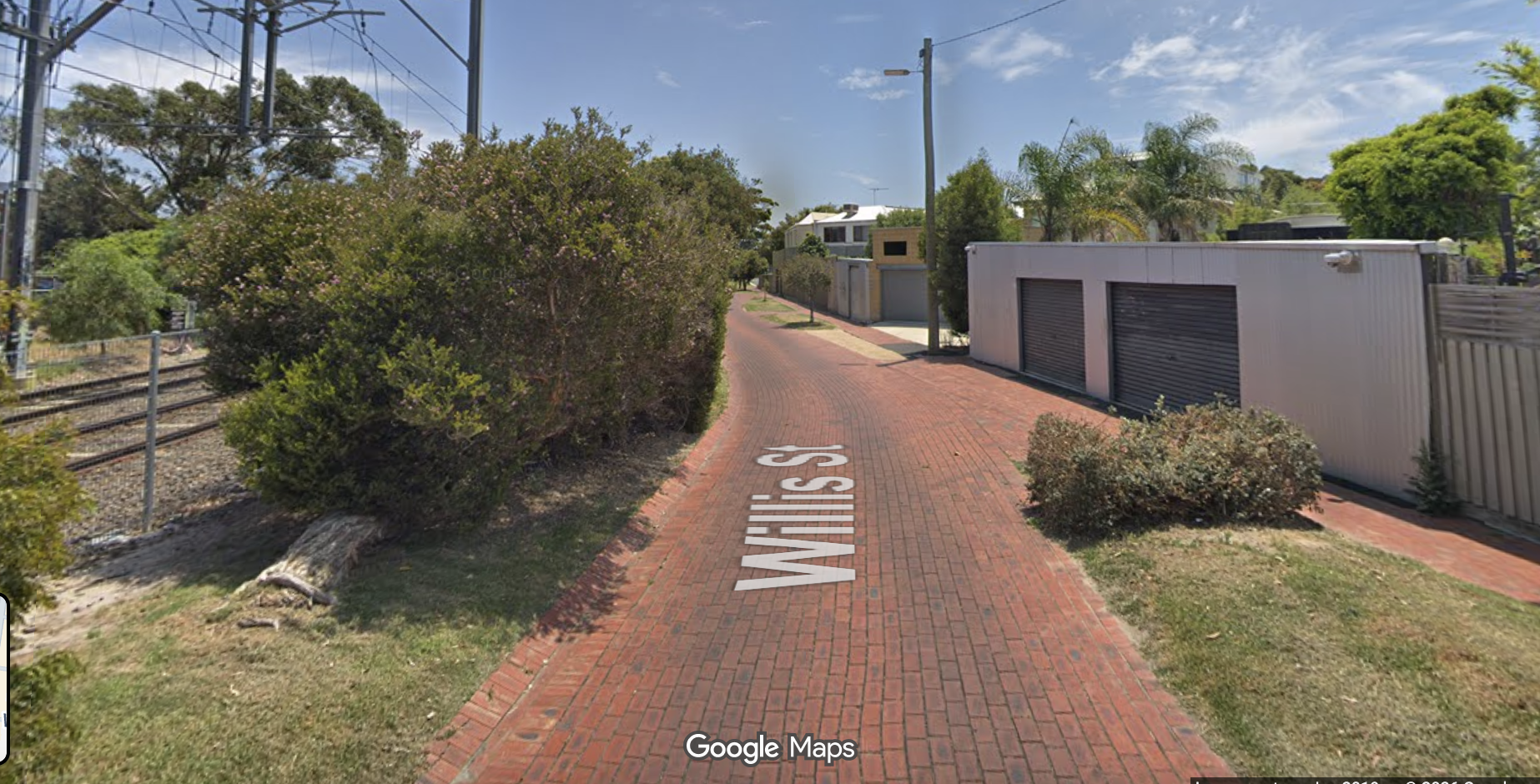
Willis St, east side of rail corridor

  • Hampton station to Beach Rd via Hampton St. Near Hampton Station this is a busy high street with on-street parking, making this safe for active travel while keeping the on-street parking would be challenging. Further south, it is a standard two-way carriageway with on-street parking, generally not highly utilised. This would be technically straightforward to include protected bike lanes but as ever politically challenging.

  • Hampton St merges with Beach Rd. The difficulty here is providing bike infrastructure that is suitable for a wide range of cyclists, while allowing the bunch rides to maintain their current use. A standard width protected lane would not be suitable for bunch rides.

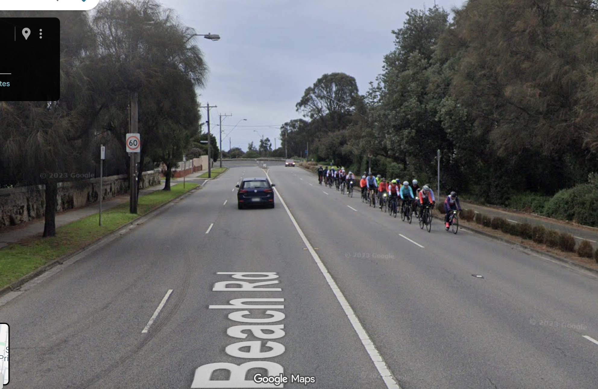
Beach Rd, with a large group (about 20) of bike rides using the outer lane.

  • The route ends at Sandringham station.

Port Phillip BUG plans to ride this route in the near future, keep an eye on our social media for dates. Comments welcomed.

Added 7/02/26: An alternate route servicing a similar catchment would be the C1 strategic route along Nepean Highway (in pink in the map above). David Blom from Metro East BUG has made a post about how this route could work (facebook ).

Newly revealed plans show Council and State govt blocked a beautiful boulevard on Kerferd Rd with safe green transport links

Bike Melbourne and the Port Phillip Bicycle Users Group have received plans for the Shrine to Sea proposal, under an FOI application.

Aerial photo of a boulevard with wide grassy median, with city skyline in background

Kerferd Rd is one of the City of Port Phillip’s planned network of safe cycle routes.   It links Anzac Station, and the protected bike lanes on St Kilda Rd, with the beach and the Bay Trail.  It runs past several schools, the Moray St bike lanes, MSAC and Albert Park.   Kerferd Rd has one of the highest crash rates for Council-controlled roads. 

The documents show that the planned protected bike lane delivered the on the priorities set by the community. Councillors scuttled the state government funded project in 2023 without substantive justification. The community has missed out on the investment, the improved landscaping, and the safety benefits to all users.

An infographic showing number and location of crashes on Kerferd Rd

Shrine to Sea history

The original Shrine to Sea plan was to improve the boulevard that runs from the Shrine of Remembrance, along Albert Rd past Albert Park, and then down Kerferd Rd to the beach.   

A diverse community panel met extensively online during the pandemic to discuss the priorities for the community, the opportunities and constraints. The community panel’s recommendations are here.   Among the recommendations:  Bike lanes to be interconnected for the entire length of the boulevard (LC01) and Use landscaping to define a separate bike pathway on Kerferd Road to isolate bikes from cars (LC08).    In Nov 2021, DELWP mostly supported these recommendations, though they noted that in places shared paths would be used instead of dedicated on-road lanes.   

A streetscape, showing a grassy median with trees, traffic lane, parking lane with silver car, planting with flowers, bike lane crossed by a pedestrian crossing, nature strip, footpath.  There is a person crossing with a pram.

The protected bike lane would also improve connections to the car parking, and include extra planting.

Despite this initial positive assessment, pressure by councillors led to the State government dropping the protected bike lane aspect of the project. In 2023 the State Government “decided that further targeted engagement is required for a safer active transport solution along Kerferd Road. For this reason, the protected bike lane is being separated from the Shrine to Sea masterplan to be considered at a future time”.  

Decision making 

There were community campaigns both for and against the separated bike lane.   Opponents of the separated bike lane shared a lot of misinformation, including about bin collection, parking capacity, and safety that could have been easily resolved.  It’s disappointing that those with access to the full reports did not use this information to inform the community.    We are sharing the results of the FOI to partially remedy this.

The decision to shelve the bike lanes (or “separate them from the project”) was made by State Government in May 2023 behind closed doors, under pressure from Port Phillip councillors. Port Phillip council is responsible for Kerferd Rd, and may have spooked their funding partner for any future improvements. 

At a meeting in August 2023, Council failed to support the protected bike lane aspects of the plan, and instead asked the Victorian government for support for generally ineffective measures to address crashes such as “white line-marking, green treatments at conflict points and additional regulatory signage”.  

What the documents show

There was extensive investigation of 5 design scenarios:  the current situation; a buffered bike lane; a bike lane on the median;  the protected bike lane; and a service-road bike lane (north section only). 

Each design was assessed using the Healthy Streets Design Check Tool for Australia; and through the Shrine to Sea Metric Criteria assessment which was developed in response to local resident and community feedback, policy alignment and operational needs of DEECA and CoPP.  

Under the Healthy Streets assessment tool, the protected bike lane scored highest (or equal highest between Richardson and Danks St).   The protected bike lane also scored highest under the Shrine to Sea metric criteria. 

Table showing how the different scenarios rated on the healthy streets and S2S metrics.  The protected bike lane ranks first.
Table showing how the different scenarios rate under healthy streets and S2S metrics.  Protected bike lane ranks first.

The protected bike lane scenario:

  • would preserve access to properties for people using cars, keep almost all car parks and improve access to car parks by extra crossings of the wide drain

  • be suitable for use by all micromobility modes, including scooters, trikes; and all users including kids and the elderly

  • leave sufficient capacity for vehicle traffic, with intersection modelling assessment showing that the proposed cycle infrastructure can be accommodated within the existing network without any major deterioration in intersection performance at two of the three sites evaluated. At the Ferrars/Canterbury intersection, there would be an average extra delay of 28 seconds for vehicles during the AM peak. 

  • Allow construction of safe pedestrian access to the central median

  • Include new plantings curbside

Rendering of the protected bike lane plan, showing extensive planting

Projected benefits of the protected bike lane include:

  • Increased ability of kids to ride to school, sport and around their community

  • Better cycle access to destinations like MSAC, the South Melbourne Market, Anzac Station, and the beach, leaving more car parking available for those who drive

  • Discourage hooning on Kerferd Rd through road redesign for slower speeds


Specific concerns addressed


These are concerns that were raised at the August 2023 council meeting. 

“The bike path surface will be sloped which will make it dangerous for people on trikes.”   Concept plans show a standard, flat bike lane surface, of similar width and cross-section to lanes on St Kilda Rd. This would be useable by people on bikes, scooters, mobility scooters, and trikes.

“There was no co-design process.”  The community panel went through a process informed by subject matter experts on design principles, landscaping, and accessibility.    

“This will displace vehicle traffic on to neighbourhood streets”.  This wasn’t modelled specifically (at least in the documents that were released) but there is no evidence for this available.

“One lane is not sufficient for an arterial road.” Kerferd Rd is not an arterial road.   Capacity is generally limited by intersection capacity rather than number of lanes, and modelling of intersection effects showed minimal impacts at 2 of the 3 intersections studied, and a 28 second delay during morning peak at the Ferrars/Canterbury intersection. 

“This will make it hard to access car parking”.   This was specifically studied.    In the current set-up, “pedestrians must traverse a turf nature strip, non-mountable concrete kerb and bluestone spoon drain, which in some locations is very steep and deep”.   With the  protected bike lane,   “access to the parking spaces will be enhanced by new raised crossing points that remove the existing difficulties that people with mobility issues face today due to the lack of connections to footpaths, navigating high kerbs, and having to cross steep sections of uneven bluestone paving”, a clear improvement on current conditions.

Regarding overall number of parking places:   the protected bike lane has a reduction in parking places of 14%.   According to the released documents, “The design retains sufficient car parking to cater for the demand of users based on occupancy surveys completed in Nov/Dec 2022”.  The average occupancy rate of car parks along Kerferd Rd was 59%, and it is demonstrated that “that in most sections along Kerferd Road, even when occupancy is at its highest, there is a surplus of available car bays”.

Documents referenced:

Plans received from the  FOI, including:

  Concept plans for the protected bike lane

Detailed comparison of five different scenarios

Recommendations of the community panel

City of Port Phillip Integrated Transport Strategy.


Images in this post come from Design Scenarios and Assessment for Shrine to Sea cycling corridor— Kerferd Rd.

Councillors ride March 2025: East St Kilda, Balaclava, Ripponlea, Elwood

On Tuesday the BUG took new councillors Libby Buckingham and Justin Halliday for a ride around their wards and surrounding suburbs.

From left: Julie (PPBUG); Cr Justin Halliday; Mya (PPBUG); Cr Libby Buckingham; Pierre (PPBUG and Back2bikes volunteer).

The route over St Kilda Hill is dangerous, with heavy trucks using the left-most lane alongside cyclists with only a line of paint separating the two. A door zone adds extra hazard. This is a State responsibility, but would benefit from Council support.

Over St Kilda Hill, cyclists are expected to ride alongside heavy traffic.

We also visited some excellent cycle infrastructure. Since the construction of these protected lanes on St Kilda Rd, rider numbers have increased by 200-300%.

However south of Wellington St, the protected lane ends and only a door-zone lane is provided.

We then went along Wellington St, a shimmy route— which means a bicycle route with little dedicated infrastructure, but some traffic calming and bike symbols painted on the road (sharrows).

Once in Alma Park, we rode one of the few off-road bicycle paths alongside the railway line. This is part of the proposed Green Line route.

We made our way down to Ripponlea along Williams St. At Ripponlea we discussed the possibility of reducing the speed limit to 30km/hr, as this is a high-pedestrian area, as well as a state Strategic Cycling Corridor. The only provision for cycling here is a narrow, door-zone lane. The lane also narrows rapidly after the railway crossing, creating another hazard.

We headed over to Elwood. Here we looked at the location for the long-promised signalised crossing of Glen Huntly Rd. We also looked at the road treatments at the Primary School, which includes a one-way road with drop-off zone on Poet’s Grove, and the closing of Mitford St (which has been incorporated into the primary school grounds). These are good models for the new primary school at Fishermans Bend.

Then up to Dickens St, where there is a very unsatisfactory crossing of Brighton Rd, to connect to the Primary School. Outside the primary school a new pocket park has been created, with space for kids to play and a well-used basketball hoop.

Thanks Crs Buckingham and Halliday! We wish you well in your term on Council.

Photo credit: Simon Kosmer.

St Kilda Rd separated lanes, Junction to Carlisle: lobbying our local MPs

This January, we’ve been talking our local MPs, Nina Taylor (MP for Albert Park) and Ryan Batchelor (upper house MP for Southern Metropolitan Region.

3 women and a man standing inside.  There is a cartoon of a person on a bike overlaid.

Nina Taylor (left) with Dan, Lorelle and Julie from PPBUG.

Both of them listened to our concerns about the immediate safety risks posed by the unprotected, door-zone lane in close proximity to heavy trucks; and about the need for a plan to make all the strategic cycling corridors fit for purpose.

Neither made any commitment to improve the situation or had any news that planning to fix these problems was underway.

Our meeting with Ryan Batchelor was in conjunction with our campaign partners Stonnington BUG and Bike Melbourne.

More about the campaign here.

St Kilda Road separated lanes update, Junction to Carlisle St section

The St Kilda Rd separated bike lanes project was originally announced to run from the City to Carlisle St, but during construction it was down-graded to stop at St Kilda junction. Earlier this year we found out from the office of Active Transport minister Gabrielle Williams that the project contractors have closed up their office, without passing on the design work on the remaining section.

The route over St Kilda hill is fraught with danger.   Heading north, people on bikes have an unprotected on-road lane, with heavy trucks directly alongside-- heavy traffic from the Nepean Highway tends to turn off onto Queens Rd at the junction, so will be in the left-most lane.   Heading south, there is a "door zone" on-road, unprotected lane.      Cyclists travelling down the hill are travelling at speed, giving people opening car doors into the lane even less time to make a careful check.  

MLC Katherine Copsey has raised this in Parliament.

This route is one of the main (C1) Strategic Cycling Corridors, connecting the city with Frankston. The improvements on the northern section have increased the number of users there up to 300%— which is great, but also means that more people will be using the unsatisfactory southern sections for access.

We are asking our local MPs, Nina Taylor (Albert Park) and Ryan Batchelor (Southern Metropolitan) to make funding and building this section a priority—- before some is injured or worse.

Help out: email your MPs. If you have photos, videos or a story about your experience on this section, please share it with us portphillipbug@gmail.com to add to our campaign.

Strategic Cycling Corridors: when will these be fit for purpose?

In August 2024, a 27 year old Southbank man was killed in an (alleged) hit-run on Plummer St, Port Melbourne. He was working as a food delivery rider.

Every death is a tragedy for the family and loved ones. This one is particularly sour as Plummer St is one of the sparse network of roads designated as Strategic Cycling Corridors. Plummer St is partly 4 and partly 2 lane, very wide, and characterised by fast speeds and truck traffic.    

Map of strategic cycling corridors, shown in pink and blue. Plummer St highlighted in yellow.

Strategic cycling corridors in Port Phillip. Plummer St top left, highlighted in yellow.

According to State Government, “SCCs are the main routes of the bicycle network, similar to how arterials are the main routes of the road network. They identify the most important routes for cycling for transport that connect to key destinations of metropolitan and regional significance, including key employment areas, activity centres and railway stations.”

However, unlike arterials, the conditions of the SCCs are currently massively unfit for for purpose, and there is no plan for systemically upgrading the infrastructure. Some routes have been upgraded as a by-product of other projects such as the Level Crossing Removal Project (for example, there will be a separated route on Queens Avenue, Caulfield). The local flagship project of the St Kilda Rd bike lanes took over 20 years of lobbying, during which several people were killed. (And that project remains incomplete, with only painted lanes between the Junction and Carlisle St).

Here is a scary clip from Lorimer St (also a SCC).

Screenshot from the clip (the cyclist was not squashed thank goodness).

Given the lack of progress on infrastructure, it’s fair to ask whether these are nothing but lines on the map.

Following the death in August, Port Phillip BUG wrote to Road Safety Minister Melissa Horne, asking her to prevent future injuries and deaths—- including of delivery riders at work—- by upgrading the SCC routes.

In November, we received a response from Stuart Johns, Executive Director of Modal planning.

“Victoria has adopted the safe system approach to road safety, which recognises that we as humans are vulnerable and make mistakes that shouldn’t cost us our lives. ”

For people riding bicycles or using other micromobility devices, the practical application of this approach means that on-road facilities should be physically separated from motorised traffic in environments where traffic operates at speeds of more than 30km/h. Earlier this year, DTP adopted a policy outlining that any of its new or upgraded projects that occur on SCCs should include treatments to this effect.
— Stuart Johns, Department of Transport and Planning

“Bicycle facilities, typically off-road shared use paths, are also included as part of all major state transport projects (road and rail) and a combination of off-road shared use paths and exclusive off-road bike paths are being progressively delivered as land develops in our growth areas. The policy also requires turn controls at new and significantly upgraded signalised intersections which will further improve safety for cyclists.”

Link to the new policy.

This is a long way short of a funded, systematic program that would deliver suitable infrastructure on SCC routes within any defined timeline. However it does represent a very very small shift in DTP policy. It’s not clear how many decades it would take for SCC routes to be fixed under this incremental policy.

The response did not share any plans for new or upgraded projects on Plummer St.